

- Library
- ESRI Beans Canvas • Google • Mapbox •
-
Demo Links
Beans Canvas
https://www.beans.ai/mapswidget/example-banvas.html
https://www.beans.ai/mapswidget/example-banvas-inline.html
https://www.beans.ai/mapswidget/example-banvas-with-multiple.html
ESRI
https://www.beans.ai/mapswidget/example-esri.html
https://www.beans.ai/mapswidget/example-esri-inline.html
https://www.beans.ai/mapswidget/example-esri-with-multiple.html
https://www.beans.ai/mapswidget/example-esri-with-no-3d.html
https://www.beans.ai/mapswidget/example-esri-with-multiple-no-3d.html
Google
https://www.beans.ai/mapswidget/example-google.html
https://www.beans.ai/mapswidget/example-google-inline.html
https://www.beans.ai/mapswidget/example-google-with-multiple.html
https://www.beans.ai/mapswidget/example-google-with-no-3d.html
https://www.beans.ai/mapswidget/example-google-with-multiple-no-3d.html
Mapbox
https://www.beans.ai/mapswidget/example-mapbox.html
https://www.beans.ai/mapswidget/example-mapbox-inline.html
https://www.beans.ai/mapswidget/example-mapbox-with-multiple.html
https://www.beans.ai/mapswidget/example-mapbox-with-no-3d.html
https://www.beans.ai/mapswidget/example-mapbox-with-multiple-no-3d.html
Account Setup
Please register an enterprise account on https://www.beans.ai/enterprise-console. When creating an account, you may use the invite code sent to you in a separate email.
Once you have created an account, a Beans API key and secret is automatically generated for you. Please keep these credentials confidentially and you will need to use them in the integration specification below.
Indoor API
Request
Authentication
The Beans Indoor Path API uses a standard authorization header to authenticate client requests. You must sign in and create an enterprise account here to get your key before you access the API. If you use an unauthorized key or do not provide one, you will get a NOT_ALLOWED response.
Once you have your key and secret available, you are required to specify them in the Authorization header of all your requests, as below, where a2V5OnNlY3JldA== is the base64 encoding of the string "key:secret". For more information, see wiki:Basic access authentication
Authorization: Basic a2V5OnNlY3JldA==
Request Parameters
Request Parameters Type? Required? Values waypoints Semicolon separated quadruple of
Double, Double, Double, StringYes Quadruples of Lat, Lng, Elevation, Name findBestSequence Boolean No preserveFirstStop Boolean No preserveLastStop Boolean No Example Request
$ curl -X GET \
'https://api.beans.ai/enterprise/v2/search/path?waypoints=32.8264607729915,-96.84978217271895,3.0,A;32.82701237436884,-96.84987603133914,3.0,C;32.82651059989373,-96.85022429570184,3.0,B;32.82639019340066,-96.84993787453772,3.0,D' \
-H 'Authorization: Basic a2V5OnNlY3JldA=='
Response
Response Object
Response will consist of three arrays: point, leg, and order. The response for the above sample request is belowIntegration Overview
The Beans.ai Web Widget works seamlessly across ESRI JS APIs, Beans Canvas, Mapbox, and Google Maps.
There are two primary ways to integrate the Beans.ai Web Widget.
- Library
In the library implementation, you will code and host the web pages necessary to render the widget. This is ideal for an integration where the widget lies within your website and is embedded in an existing page. The widget allows far more customization than the Beans.ai hosted iFrame/ Web View integration. - Hosted by Beans.ai
In the Beans.ai hosted implementation, you will simply link to the widget hosted on the Beans.ai website and embed it either within your website in iframe, or as an external link from your website, or within your mobile app as a Web View using URL query parameters to specify the data you want to display.
Configuration
ESRI Integration
Headers<link href="https://www.beans.ai/mapswidget/css/mapswidget-1.0.4.css" rel="stylesheet" /> <link href="https://js.arcgis.com/4.23/esri/themes/light/main.css" rel="stylesheet" /><script type="text/javascript" src="https://js.arcgis.com/4.23/" ></script> <script type="text/javascript" src="https://www.beans.ai/mapswidget/js/mapswidget-1.0.4.js" ></script><div id="beans-maps-1" style="width: 50vw; height: 60vh;"></div>
Initializing
The following is an example of the code that must be added to the body right after the two js files above:
Basic Rendering<script type="text/javascript"> var be = new BeansMap(); be.render( "beans-maps-1", "...beans api key:secret...", [ { address: "3815 N 16th St, Phoenix, AZ", unit: "251" } ], // Nav Options, {}, // Display Options {}, // Callback Options {} ); </script>
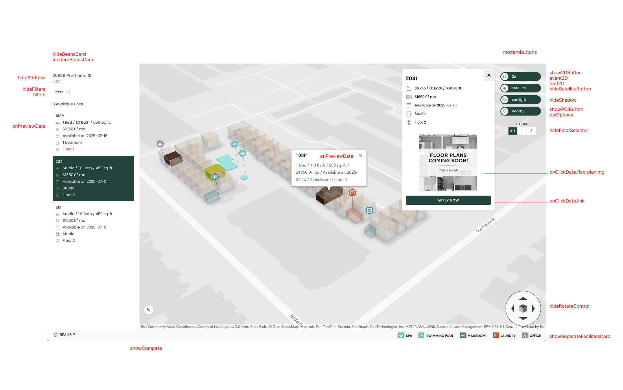
Customizations<script type="text/javascript"> var be = new BeansMap(); be.render( "beans-maps-1", "...beans api key:secret...", [ { address: "1200 Dale Ave, Mountain View, CA", unit: "43", options: { // [Optional] If unit list is displayed, the lines to display below each unit number. // This also controls the display on hover and the display in the click box. onPreviewData: [ { value: "3 Bed / 2 Bath / 1500 sq. ft." }, { value: "$3200/ mo" }, { value: "Available Now" } ], // [Optional] Content used for filtering in the unit list, and to control the actions in the box when // the unit is selected. If omitted, filters will malfunction, and no popup will be shown on selection. // Despite the nomenclature, the data that actually gets displayed in the popup is primarily from // onPreviewData, except for the the two actionable things: floorplanImg and link, which are read // from onClickData. onClickData: { name: "43", bed: 3, bath: 2, sqft: 1500, rent: 3200, floorplanImg: "...", link: "..." }, // [Optional] The HTML content to show on hover. Takes priority over onPreviewData. onPreviewContent: "<div>...</div>", // [Optional] The HTML content to show in the click box. Takes priority over onPreviewData. onClickContent: "<div>...</div>", // [Optional] Design of the unit. unitShape: { fillColor: '#427B01', fillOpacity: 1.0, strokeWeight: 1.0, strokeOpacity: 1.0, strokeColor: '#ffffff' }, tiles: { keybox: { // [Optional] Set the text to show on the tiles. text: "#9112", // [Optional] Set the icon for the tile. See // https://storage.googleapis.com/beans-mobile-resources/marker-note-icons/parking_0.png // for size and format. iconUrl: "https://storage.googleapis.com/beans-mobile-resources/marker-note-icons/..." }, entrance: { text: "#9111" }, elevation: { text: "Floor 3" }, parking: { text: "Street" } }, markers: { // [Optional] Set display to false to hide all the markers. Default true. display: true, keybox: { // [Optional] Set display to true to show the marker if all the markers are hidden // [Optional] Set display to false to hide the marker if all the markers are visible display: true, // [Optional] Set the text to show on the markers. text: "#9112" }, entrance: { text: "#9111", // [Optional] Set the icon for the marker. See // https://storage.googleapis.com/beans-mobile-resources/marker-note-icons/parking_0.png // for size and format. iconUrl: "https://storage.googleapis.com/beans-mobile-resources/marker-note-icons/..." }, elevation: { text: "Floor 3" }, parking: { text: "Street" } }, poi: [ { // [Required] Set the POI location. location: { lat: 33.63427078772915, lng: -111.86407107998963 }, // [Required] Set the POI type. name: "CARWASH", // [Optional] Set the icon for the POI. See // https://storage.googleapis.com/beans-mobile-resources/marker-note-icons/parking_0.png // for size and format. iconUrl: "https://storage.googleapis.com/beans-mobile-resources/marker-note-icons/..." }, { // [Optional] Set display to false to hide specific POIs that are a part of the Beans data set. display: false, // [Required] Set the POI type. name: "TRASH" }, { display: false, name: "ALL" } ] } } ], { // [Optional] Set the location of the user to a fixed position for the navigation to work. userLocation: { lat: 37.450469700667234, lng: -122.16778683875827 }, // [Optional] Alteratenely, set the user location to pick the current live location the user. // userLocation: "LIVE", // [Optional] Set the default maps app to open on clicking the navigate button. platform: "APPLE", // [Optional] Hide the navigate button hideNavigateButton: true, // [Optional] Hide the "my location" button. hideMyLocationButton: true }, { // [Optional] Set the default view to satellite. initialMap: "SATELLITE", // [Optional] Show an edge-to-edge Beans card vs a card contained inside the map. modernBeansCard: true, // [Optional] Hide the beans card. hideBeansCard: true, // [Optional] Show the preview data inside the Beans card instead of a popup. inlineClickData: true, // [Optional] Hide the filters. hideFilters: true, // [Optional] Show the bigger, descriptive version of buttons instead of circles. modernButtons: true, // [Optional] Hide the toggle satellite view button. hideSatelliteButton: true, // [Optional] Hide the toggle shadow view button. hideShadow: true, // [Optional] Show a button that reads 2D map. show2DButton: true, // [Optional] JS function to run of clicking the 2D button. Takes preference over href2D. event2D: function() {}, // [Optional] Href on clicking the 2D button href2D: "...", // [Optional] Show a button that to reads 3D map. show3DButton: true, // [Optional] JS function to run of clicking the 3D button. Takes preference over href3D. event3D: function() {}, // [Optional] Href on clicking the 3D button href3D: "...", // [Optional] Hides the rotation control. hideRotateControl: true, // [Optional] Show a bottom bar with index of facilities. showSeparateFacilitiesCard: true, // [Optional] Hide the floor selector list. hideFloorSelector: true, // [Optional] Show the toggle nearby POI button. showPOIButton: true, // [Optional] Override default filters. filters: { bed: { name: "Bedrooms", values: [ {type: "all", name: "Any"}, {type: "range", value1: "1", value2: "2", name: "1BR"}, {type: "range", value1: "2", value2: "3", name: "2BR"}, {type: "min", value1: "3", name: "3BR+"} ] }, status: { name: "Status", values: [ {type: "all", name: "Any"}, {type: "string", value: "Open for Sale", name: "Open for Sale"}, {type: "string", value: "Sold", name: "Sold"} ] }, bath: { name: "Bathrooms", values: [ {type: "all", name: "Any"}, {type: "min", value1: "1", name: "1BA+"}, {type: "min", value1: "2", name: "2BA+"}, {type: "min", value1: "3", name: "3BA+"} ] }, sqft: { name: "Area", values: [ {type: "all", name: "Any"}, {type: "range", value1: "0", value2: "500", name: "0-500"}, {type: "range", value1: "500", value2: "1000", name: "500-1000"}, {type: "range", value1: "1000", value2: "1500", name: "1000-1500"}, {type: "min", value1: "1500", name: "1500+"} ] } }, // [Optional] Override the POI list. // The type can be an arbitrary string. // The label is what is shown on the sliding card. // The value is the category on Google Places. // List available at https://developers.google.com/maps/documentation/places/web-service/place-types#table-a. // The icon is the url of the icon to be displayed in the sliding card. // List available at https://api.beans.ai/enterprise/v2/search/notes/markers/info poi: [ { type: "FOOD", label: "Restaurants", value: "restaurant", icon: "https://storage.googleapis.com/beans-mobile-resources/marker-note-icons/food_0.png" }, { type: "HOSPITAL", label: "Hospitals", value: "hospital", icon: "https://storage.googleapis.com/beans-mobile-resources/marker-note-icons/hospital_0.png" }, { type: "SCHOOL", label: "Schools", value: "school", icon: "https://storage.googleapis.com/beans-mobile-resources/marker-note-icons/school_0.png" }, { type: "COLLEGE", label: "Colleges", value: "college", icon: "https://storage.googleapis.com/beans-mobile-resources/marker-note-icons/school_0.png" } ], // [Optional] Show the unit, entrance, elevator tiles. showTiles: true, // [Optional] Show the distance links. showLinks: true, // [Optional] Show unit outline. showUnitShape: true, // [Optional] Show the multi-unit selector in the card. showUnitList: true, // [Optional] Show the 3D map with real-ground elevation. useGroundElevation: true, // [Optional] Offset the building's base by this elevation. // Must be specified when useGroundElevation is true. offsetGroundElevation: 3, // [Optional] Enable neighborgood buildings button. showNeighbors: true, // Initial tilt, heading, and Z must be accompanied with initialPosition. Alternately, use camera. // [Optional] Initial tilt of the camera. 0 is looking down vertically. initialTilt: 30, // [Optional] Initial height of the camera. initialZ: 400, // [Optional] Initial view direction of the camera. 0 is North. initialHeading: 270, // [Optional] Initial position of the camera. initialPosition: {lat: 40.05, lng: -86.14}, // [Optional] Initial camera angle — combination of lat, lng, z, heading, and tilt camera: {tilt: 64.82, heading: 269, position: {x: -86.14, y: 40.05, z: 122.45}}, // [Optional] Show building outline. showBuildingShape: true, // [Optional] Show directions in the card. showDirections: true, // [Optional] Show navigation path. showPath: true, // [Optional] Set the order of the path. path: [ "PARKING", "ENTRANCE", "ELEVATOR", "UNIT" ], // [Optional] Default design of every unit. unitShape: { fillColor: '#ffffff', fillOpacity: 0.5, strokeWeight: 1, strokeOpacity: 0.2, strokeColor: '#000000', fillColorOnShadowMode: '#ffffff', fillOpacityOnShadowMode: 1.0, fillColorOnNeighborMode: '#B7E5A6', fillOpacityOnNeighborMode: 1.0 }, // [Optional] Design of every unit on the selected floor. selectedUnitShapeSameFloor: { fillColor: '#427B01', fillOpacity: 1.0, strokeWeight: 1.0, strokeOpacity: 1.0, strokeColor: '#ffffff' }, // [Optional] Design of the selected unit. selectedUnitShape: { fillColor: '#FFB20F', fillOpacity: 1.0, strokeWeight: 1.0, strokeOpacity: 1.0, strokeColor: '#ffffff' }, // [Optional] Design of every unit that can be selected. selectableUnitShape: { fillColor: '#427B01', fillOpacity: 1.0, strokeWeight: 1.0, strokeOpacity: 1.0, strokeColor: '#ffffff' }, // [Optional] Design of other buildings when neighborhood is viewed. neighborShape: { fillColor: '#ffffff', fillOpacity: 1.0, strokeWeight: 1.0, strokeOpacity: 0.2, strokeColor: '#000000' } }, // Callback Options { onSatelliteClick: (type) => {}, // STREET or SATELLITE onMylocationClick: (isFound, {lat: ..., lng: ...}) => {}, onPOINavigateClick: (searchQuery) => {}, onShareButtonClick: () => {}, onHelpButtonClick: () => {}, onPOIClick: (markerName) => {}, onMinimizeCard: () => {}, onMaximizeCard: () => {}, onSelect: (onClickData) => {} } ); </script>
BeansMap.prototype.render takes the following parameters, in order:- ID of the div that the widget should render within
- Beans api “key:secret”
- Array of Display objects, where each Display object consists of:
- Street address.
- Unit address. Leave empty if no unit number is required.
- Options. Every field in Options is optional, and provides mechanisms to override different parts of the display. You may pass
- OnPreviewData
- OnClickData
- Tiles
- Markers
- Additional points of interest, which must have the name from the following strings: SWIMMINGPOOL, CARWASH, TENNIS, LAUNDRY, OFFICE, CLUBHOUSE, BBQ, MAILROOM, PACKAGELOCKER, CYCLESTORAGE, GYM
- Navigation options. Every field in Navigation Options is optional. You may pass
- UserLocation
- Platform
- HideNavigateButton
- Display options. Every field in Display Options is optional. You may pass
- InitialMap
- MapSyle
- HideNavigateButton
- HideBeansCard
- HideFloorSelector
- ShowTiles
- ShowLinks
- ShowDirections
- ShowUnitShape
- ShowUnitList
- UseGroundElevation
- OffsetGroundElevation
- ShowNeighbors
- InitialTilt
- InitialZ
- InitialHeading
- ShowBuildingShape
- ShowPath
- Path
- UnitShape
- SelectedUnitShapeSameFloor
- SelectedUnitShape
- SelectableUnitShape
- NeighborShape
Beans Canvas Integration
Headers<link href="https://www.beans.ai/mapswidget/css/mapswidget-1.0.4.css" rel="stylesheet" /><script type="text/javascript" src="https://www.beans.ai/mapswidget/js/banvas.js" ></script> <script type="text/javascript" src="https://www.beans.ai/mapswidget/js/mapswidget-1.0.4.js" ></script><div id="beans-maps-1" style="width: 50vw; height: 60vh;"></div>
Initializing
The following is an example of the code that must be added to the body right after the two js files above:
Basic Rendering<script type="text/javascript"> var be = new BeansMap(); be.render( "beans-maps-1", "...beans api key:secret...", [ { address: "3815 N 16th St, Phoenix, AZ", unit: "251" } ], // Nav Options, {}, // Display Options {}, // Callback Options {} ); </script>
Customizations<script type="text/javascript"> var be = new BeansMap(); be.render( "beans-maps-1", "...beans api key:secret...", [ { address: "1200 Dale Ave, Mountain View, CA", unit: "43", options: { // [Optional] If unit list is displayed, the lines to display below each unit number. // This also controls the display on hover and the display in the click box. onPreviewData: [ { value: "3 Bed / 2 Bath / 1500 sq. ft." }, { value: "$3200/ mo" }, { value: "Available Now" } ], // [Optional] Content used for filtering in the unit list, and to control the actions in the box when // the unit is selected. If omitted, filters will malfunction, and no popup will be shown on selection. // Despite the nomenclature, the data that actually gets displayed in the popup is primarily from // onPreviewData, except for the the two actionable things: floorplanImg and link, which are read // from onClickData. onClickData: { name: "43", bed: 3, bath: 2, sqft: 1500, rent: 3200, floorplanImg: "...", link: "..." }, // [Optional] The HTML content to show on hover. Takes priority over onPreviewData. onPreviewContent: "<div>...</div>", // [Optional] The HTML content to show in the click box. Takes priority over onPreviewData. onClickContent: "<div>...</div>", // [Optional] Design of the unit. unitShape: { fillColor: '#427B01', fillOpacity: 1.0, strokeWeight: 1.0, strokeOpacity: 1.0, strokeColor: '#ffffff' }, tiles: { keybox: { // [Optional] Set the text to show on the tiles. text: "#9112", // [Optional] Set the icon for the tile. See // https://storage.googleapis.com/beans-mobile-resources/marker-note-icons/parking_0.png // for size and format. iconUrl: "https://storage.googleapis.com/beans-mobile-resources/marker-note-icons/..." }, entrance: { text: "#9111" }, elevation: { text: "Floor 3" }, parking: { text: "Street" } }, markers: { // [Optional] Set display to false to hide all the markers. Default true. display: true, keybox: { // [Optional] Set display to true to show the marker if all the markers are hidden // [Optional] Set display to false to hide the marker if all the markers are visible display: true, // [Optional] Set the text to show on the markers. text: "#9112" }, entrance: { text: "#9111", // [Optional] Set the icon for the marker. See // https://storage.googleapis.com/beans-mobile-resources/marker-note-icons/parking_0.png // for size and format. iconUrl: "https://storage.googleapis.com/beans-mobile-resources/marker-note-icons/..." }, elevation: { text: "Floor 3" }, parking: { text: "Street" } }, poi: [ { // [Required] Set the POI location. location: { lat: 33.63427078772915, lng: -111.86407107998963 }, // [Required] Set the POI type. name: "CARWASH", // [Optional] Set the icon for the POI. See // https://storage.googleapis.com/beans-mobile-resources/marker-note-icons/parking_0.png // for size and format. iconUrl: "https://storage.googleapis.com/beans-mobile-resources/marker-note-icons/..." }, { // [Optional] Set display to false to hide specific POIs that are a part of the Beans data set. display: false, // [Required] Set the POI type. name: "TRASH" }, { display: false, name: "ALL" } ] } } ], { // [Optional] Set the location of the user to a fixed position for the navigation to work. userLocation: { lat: 37.450469700667234, lng: -122.16778683875827 }, // [Optional] Alteratenely, set the user location to pick the current live location the user. // userLocation: "LIVE", // [Optional] Set the default maps app to open on clicking the navigate button. platform: "APPLE", // [Optional] Hide the navigate button hideNavigateButton: true, // [Optional] Hide the "my location" button. hideMyLocationButton: true }, { // [Optional] Set the default view to satellite. initialMap: "SATELLITE", // [Optional] Show an edge-to-edge Beans card vs a card contained inside the map. modernBeansCard: true, // [Optional] Hide the beans card. hideBeansCard: true, // [Optional] Show the preview data inside the Beans card instead of a popup. inlineClickData: true, // [Optional] Hide the filters. hideFilters: true, // [Optional] Show the bigger, descriptive version of buttons instead of circles. modernButtons: true, // [Optional] Hide the toggle satellite view button. hideSatelliteButton: true, // [Optional] Show a button that reads 2D map. show2DButton: true, // [Optional] JS function to run of clicking the 2D button. Takes preference over href2D. event2D: function() {}, // [Optional] Href on clicking the 2D button href2D: "...", // [Optional] Show a button that to reads 3D map. show3DButton: true, // [Optional] JS function to run of clicking the 3D button. Takes preference over href3D. event3D: function() {}, // [Optional] Href on clicking the 3D button href3D: "...", // [Optional] Hides the rotation control. hideRotateControl: true, // [Optional] Show a bottom bar with index of facilities. showSeparateFacilitiesCard: true, // [Optional] Hide the floor selector list. hideFloorSelector: true, // [Optional] Override default filters. filters: { bed: { name: "Bedrooms", values: [ {type: "all", name: "Any"}, {type: "range", value1: "1", value2: "2", name: "1BR"}, {type: "range", value1: "2", value2: "3", name: "2BR"}, {type: "min", value1: "3", name: "3BR+"} ] }, status: { name: "Status", values: [ {type: "all", name: "Any"}, {type: "string", value: "Open for Sale", name: "Open for Sale"}, {type: "string", value: "Sold", name: "Sold"} ] }, bath: { name: "Bathrooms", values: [ {type: "all", name: "Any"}, {type: "min", value1: "1", name: "1BA+"}, {type: "min", value1: "2", name: "2BA+"}, {type: "min", value1: "3", name: "3BA+"} ] }, sqft: { name: "Area", values: [ {type: "all", name: "Any"}, {type: "range", value1: "0", value2: "500", name: "0-500"}, {type: "range", value1: "500", value2: "1000", name: "500-1000"}, {type: "range", value1: "1000", value2: "1500", name: "1000-1500"}, {type: "min", value1: "1500", name: "1500+"} ] } }, // [Optional] Show the unit, entrance, elevator tiles. showTiles: true, // [Optional] Show the distance links. showLinks: true, // [Optional] Show unit outline. showUnitShape: true, // [Optional] Show the multi-unit selector in the card. showUnitList: true, // [Optional] Show building outline. showBuildingShape: true, // [Optional] Show unit numbers on the map. showNumbers: true, // [Optional] Show directions in the card. showDirections: true, // [Optional] Show navigation path. showPath: true, // [Optional] Set the order of the path. path: [ "PARKING", "ENTRANCE", "ELEVATOR", "UNIT" ], // [Optional] Default design of every unit. unitShape: { fillColor: '#ffffff', fillOpacity: 0.5, strokeWeight: 1, strokeOpacity: 0.2, strokeColor: '#000000', fillColorOnShadowMode: '#ffffff', fillOpacityOnShadowMode: 1.0, fillColorOnNeighborMode: '#B7E5A6', fillOpacityOnNeighborMode: 1.0 }, // [Optional] Design of every unit on the selected floor. selectedUnitShapeSameFloor: { fillColor: '#427B01', fillOpacity: 1.0, strokeWeight: 1.0, strokeOpacity: 1.0, strokeColor: '#ffffff' }, // [Optional] Design of the selected unit. selectedUnitShape: { fillColor: '#FFB20F', fillOpacity: 1.0, strokeWeight: 1.0, strokeOpacity: 1.0, strokeColor: '#ffffff' }, // [Optional] Design of every unit that can be selected. selectableUnitShape: { fillColor: '#427B01', fillOpacity: 1.0, strokeWeight: 1.0, strokeOpacity: 1.0, strokeColor: '#ffffff' }, // [Optional] Design of other buildings when neighborhood is viewed. neighborShape: { fillColor: '#ffffff', fillOpacity: 1.0, strokeWeight: 1.0, strokeOpacity: 0.2, strokeColor: '#000000' } }, // Callback Options { onSatelliteClick: (type) => {}, // STREET or SATELLITE onMylocationClick: (isFound, {lat: ..., lng: ...}) => {}, onPOINavigateClick: (searchQuery) => {}, onShareButtonClick: () => {}, onHelpButtonClick: () => {}, onPOIClick: (markerName) => {}, onMinimizeCard: () => {}, onMaximizeCard: () => {}, onSelect: (onClickData) => {} } ); </script>
BeansMap.prototype.render takes the following parameters, in order:- ID of the div that the widget should render within
- Beans api “key:secret”
- Array of Display objects, where each Display object consists of:
- Street address.
- Unit address. Leave empty if no unit number is required.
- Options. Every field in Options is optional, and provides mechanisms to override different parts of the display. You may pass
- OnPreviewData
- OnClickData
- Tiles
- Markers
- Additional points of interest, which must have the name from the following strings: SWIMMINGPOOL, CARWASH, TENNIS, LAUNDRY, OFFICE, CLUBHOUSE, BBQ, MAILROOM, PACKAGELOCKER, CYCLESTORAGE, GYM
- Navigation options. Every field in Navigation Options is optional. You may pass
- UserLocation
- Platform
- HideNavigateButton
- Display options. Every field in Display Options is optional. You may pass
- InitialMap
- MapSyle
- HideNavigateButton
- HideBeansCard
- HideFloorSelector
- ShowTiles
- ShowLinks
- ShowDirections
- ShowUnitShape
- ShowUnitList
- UseGroundElevation
- OffsetGroundElevation
- ShowNeighbors
- InitialTilt
- InitialZ
- InitialHeading
- ShowBuildingShape
- ShowPath
- Path
- UnitShape
- SelectedUnitShapeSameFloor
- SelectedUnitShape
- SelectableUnitShape
- NeighborShape
Google Maps Integration
Headers<link href="https://www.beans.ai/mapswidget/css/mapswidget-1.0.4.css" rel="stylesheet" /><script type="text/javascript" src="https://www.beans.ai/mapswidget/js/mapswidget-1.0.4.js" ></script> <script async defer src="https://maps.googleapis.com/maps/api/js?key=...&callback=initMap" ></script><div id="beans-maps-1" style="width: 50vw; height: 60vh;"></div>
The following is an example of the code that must be added to the body right after the two js files above:
Basic Rendering<script type="text/javascript"> function initMap() { var be = new BeansMap(); be.render( "beans-maps-1", "...beans api key:secret...", [ { address: "3815 N 16th St, Phoenix, AZ", unit: "251" } ], // Nav Options, {}, // Display Options {}, // Callback Options {} ); } </script>
Customizations<script type="text/javascript"> function initMap() { var be = new BeansMap(); be.render( "beans-maps-1", "...beans api key:secret...", [ { address: "1200 Dale Ave, Mountain View, CA", unit: "43", options: { // [Optional] If unit list is displayed, the lines to display below each unit number. // This also controls the display on hover and the display in the click box. onPreviewData: [ { value: "3 Bed / 2 Bath / 1500 sq. ft." }, { value: "$3200/ mo" }, { value: "Available Now" } ], // [Optional] Content used for filtering in the unit list, and to control the actions in the box when // the unit is selected. If omitted, filters will malfunction, and no popup will be shown on selection. // Despite the nomenclature, the data that actually gets displayed in the popup is primarily from // onPreviewData, except for the the two actionable things: floorplanImg and link, which are read // from onClickData. onClickData: { name: "43", bed: 3, bath: 2, sqft: 1500, rent: 3200, floorplanImg: "...", link: "..." }, // [Optional] The HTML content to show on hover. Takes priority over onPreviewData. onPreviewContent: "<div>...</div>", // [Optional] The HTML content to show in the click box. Takes priority over onPreviewData. onClickContent: "<div>...</div>", // [Optional] Design of the unit. unitShape: { fillColor: "#ffffff", fillOpacity: 1.0, strokeColor: "#000000", strokeWeight: 2, strokeOpacity: 1.0 }, tiles: { keybox: { // [Optional] Set the text to show on the tiles. text: "#9112", // [Optional] Set the icon for the tile. See // https://storage.googleapis.com/beans-mobile-resources/marker-note-icons/parking_0.png // for size and format. iconUrl: "https://storage.googleapis.com/beans-mobile-resources/marker-note-icons/..." }, entrance: { text: "#9111" }, elevation: { text: "Floor 3" }, parking: { text: "Street" } }, markers: { // [Optional] Set display to false to hide all the markers. Default true. display: true, keybox: { // [Optional] Set display to true to show the marker if all the markers are hidden // [Optional] Set display to false to hide the marker if all the markers are visible display: true, // [Optional] Set the text to show on the markers. text: "#9112" }, entrance: { text: "#9111", // [Optional] Set the icon for the marker. See // https://storage.googleapis.com/beans-mobile-resources/marker-note-icons/parking_0.png // for size and format. iconUrl: "https://storage.googleapis.com/beans-mobile-resources/marker-note-icons/..." }, elevation: { text: "Floor 3" }, parking: { text: "Street" } }, poi: [ { // [Optional] Set the POI location for customer markers. location: { lat: 33.63427078772915, lng: -111.86407107998963 }, // [Required] Set the POI type and id. name: "CARWASH:79d091c8-696e-4d1f-8b7e-a5e6a6b122d6", // [Optional] Set the icon for the POI. See // https://storage.googleapis.com/beans-mobile-resources/marker-note-icons/parking_0.png // for size and format. iconUrl: "https://storage.googleapis.com/beans-mobile-resources/marker-note-icons/...", // [Optional] Set display to false to hide specific POIs that are a part of the Beans data set. display: false }, { // [Required] Set the POI location. location: { lat: 33.63427078772915, lng: -111.86407107998963 }, // [Required] Set the POI type. name: "CARWASH", // [Optional] Set the icon for the POI. See // https://storage.googleapis.com/beans-mobile-resources/marker-note-icons/parking_0.png // for size and format. iconUrl: "https://storage.googleapis.com/beans-mobile-resources/marker-note-icons/..." }, { // [Optional] Set display to false to hide specific POIs that are a part of the Beans data set. display: false, // [Required] Set the POI type. name: "TRASH" }, { display: false, name: "ALL" } ] } } ], { // [Optional] Set the location of the user to a fixed position for the navigation to work. userLocation: "LIVE", // [Optional] Set the default maps app to open on clicking the navigate button platform: "APPLE", // [Optional] Hide the navigate button hideNavigateButton: true, // [Optional] Hide the "my location" button. hideMyLocationButton: true }, { // [Optional] Set the default view to satellite. initialMap: "SATELLITE", // [Optional] Set a customized Google style. mapStyle: [ { "elementType": "labels", "stylers": [ { "visibility": "off" } ] }, { "featureType": "administrative.land_parcel", "stylers": [ { "visibility": "off" } ] }, { "featureType": "administrative.neighborhood", "stylers": [ { "visibility": "off" } ] } ], // [Optional] Show an edge-to-edge Beans card vs a card contained inside the map. modernBeansCard: true, // [Optional] Hide the beans card. hideBeansCard: true, // [Optional] Show the preview data inside the Beans card instead of a popup. inlineClickData: true, // [Optional] Hide the filters. hideFilters: true, // [Optional] Show the bigger, descriptive version of buttons instead of circles. modernButtons: true, // [Optional] Hide the toggle satellite view button. hideSatelliteButton: true, // [Optional] Hide the toggle shadow view button. hideShadow: true, // [Optional] Show a button that reads 2D map. show2DButton: true, // [Optional] JS function to run of clicking the 2D button. Takes preference over href2D. event2D: function() {}, // [Optional] Href on clicking the 2D button href2D: "...", // [Optional] Show a button that to reads 3D map. show3DButton: true, // [Optional] JS function to run of clicking the 3D button. Takes preference over href3D. event3D: function() {}, // [Optional] Href on clicking the 3D button href3D: "...", // [Optional] Show a bottom bar with index of facilities. showSeparateFacilitiesCard: true, // [Optional] Hide the floor selector list. hideFloorSelector: true, // [Optional] Show the toggle nearby POI button. showPOIButton: true, // [Optional] Override default filters. filters: { bed: { name: "Bedrooms", values: [ {type: "all", name: "Any"}, {type: "range", value1: "1", value2: "2", name: "1BR"}, {type: "range", value1: "2", value2: "3", name: "2BR"}, {type: "min", value1: "3", name: "3BR+"} ] }, status: { name: "Status", values: [ {type: "all", name: "Any"}, {type: "string", value: "Open for Sale", name: "Open for Sale"}, {type: "string", value: "Sold", name: "Sold"} ] }, bath: { name: "Bathrooms", values: [ {type: "all", name: "Any"}, {type: "min", value1: "1", name: "1BA+"}, {type: "min", value1: "2", name: "2BA+"}, {type: "min", value1: "3", name: "3BA+"} ] }, sqft: { name: "Area", values: [ {type: "all", name: "Any"}, {type: "range", value1: "0", value2: "500", name: "0-500"}, {type: "range", value1: "500", value2: "1000", name: "500-1000"}, {type: "range", value1: "1000", value2: "1500", name: "1000-1500"}, {type: "min", value1: "1500", name: "1500+"} ] } }, // [Optional] Override the POI list. // The type can be an arbitrary string. // The label is what is shown on the sliding card. // The value is the category on Google Places. // List available at https://developers.google.com/maps/documentation/places/web-service/place-types#table-a. // The icon is the url of the icon to be displayed in the sliding card. // List available at https://api.beans.ai/enterprise/v2/search/notes/markers/info poi: [ { type: "FOOD", label: "Restaurants", value: "restaurant", icon: "https://storage.googleapis.com/beans-mobile-resources/marker-note-icons/food_0.png" }, { type: "HOSPITAL", label: "Hospitals", value: "hospital", icon: "https://storage.googleapis.com/beans-mobile-resources/marker-note-icons/hospital_0.png" }, { type: "SCHOOL", label: "Schools", value: "school", icon: "https://storage.googleapis.com/beans-mobile-resources/marker-note-icons/school_0.png" }, { type: "COLLEGE", label: "Colleges", value: "college", icon: "https://storage.googleapis.com/beans-mobile-resources/marker-note-icons/school_0.png" } ], // [Optional] Show the unit, entrance, elevator tiles. showTiles: true, // [Optional] Show the distance links. showLinks: true, // [Optional] Show unit outline. showUnitShape: true, // [Optional] Show the multi-unit selector in the card. showUnitList: true, // [Optional] Initial tilt of the camera. 0 is looking down vertically. initialTilt: 30, // [Optional] Initial view direction of the camera. 0 is North. initialHeading: 270, // [Optional] Initial position of the camera. initialPosition: {lat: 40.05, lng: -86.14}, // [Optional] Show building outline. showBuildingShape: true, // [Optional] Show unit numbers on the map. showNumbers: true, // [Optional] Show directions in the card. showDirections: true, // [Optional] Show navigation path. showPath: true, // [Optional] Set the order of the path. path: [ "PARKING", "ENTRANCE", "ELEVATOR", "UNIT" ], // [Optional] Default design of every unit. unitShape: { fillColor: '#ffffff', fillOpacity: 0.5, strokeWeight: 1, strokeOpacity: 0.2, strokeColor: '#000000', fillColorOnShadowMode: '#ffffff', fillOpacityOnShadowMode: 1.0, fillColorOnNeighborMode: '#B7E5A6', fillOpacityOnNeighborMode: 1.0 }, // [Optional] Design of every unit on the selected floor. selectedUnitShapeSameFloor: { fillColor: '#427B01', fillOpacity: 1.0, strokeWeight: 1.0, strokeOpacity: 1.0, strokeColor: '#ffffff' }, // [Optional] Design of the selected unit. selectedUnitShape: { fillColor: '#FFB20F', fillOpacity: 1.0, strokeWeight: 1.0, strokeOpacity: 1.0, strokeColor: '#ffffff' }, // [Optional] Design of every unit that can be selected. selectableUnitShape: { fillColor: '#427B01', fillOpacity: 1.0, strokeWeight: 1.0, strokeOpacity: 1.0, strokeColor: '#ffffff' } }, // Callback Options { onSatelliteClick: (type) => {}, // STREET or SATELLITE onMylocationClick: (isFound, {lat: ..., lng: ...}) => {}, onPOINavigateClick: (searchQuery) => {}, onShareButtonClick: () => {}, onHelpButtonClick: () => {}, onPOIClick: (markerName) => {}, onMinimizeCard: () => {}, onMaximizeCard: () => {}, onSelect: (onClickData) => {} } ); } </script>
BeansMap.prototype.render takes the following parameters, in order:- ID of the div that the widget should render within
- Beans api “key:secret”
- Array of Display objects, where each Display object consists of:
- Street address.
- Unit address. Leave empty if no unit number is required.
- Options. Every field in Options is optional, and provides mechanisms to override different parts of the display. You may pass
- Tiles
- Markers
- Additional points of interest, which must have the name from the following strings: SWIMMINGPOOL, CARWASH, TENNIS, LAUNDRY, OFFICE, CLUBHOUSE, BBQ, MAILROOM, PACKAGELOCKER, CYCLESTORAGE, GYM
- Navigation options. Every field in Navigation Options is optional. You may pass
- UserLocation
- Platform
- HideNavigateButton
- Display options. Every field in Display Options is optional. You may pass
- InitialMap
- MapSyle
- HideNavigateButton
- HideBeansCard
- HideFloorSelector
- ShowTiles
- ShowLinks
- ShowDirections
- ShowUnitShape
- ShowUnitList
- ShowBuildingShape
- ShowPath
- Path
Mapbox Integration
Headers<link href="https://www.beans.ai/mapswidget/css/mapswidget-1.0.4.css" rel="stylesheet" /> <link href="https://api.tiles.mapbox.com/mapbox-gl-js/v2.9.1/mapbox-gl.css" rel="stylesheet" /><script type="text/javascript" src="https://api.tiles.mapbox.com/mapbox-gl-js/v2.9.1/mapbox-gl.js" ></script> <script type="text/javascript" src="https://www.beans.ai/mapswidget/js/mapswidget-1.0.4.js" ></script><div id="beans-maps-1" style="width: 50vw; height: 60vh;"></div>
Initializing
The following is an example of the code that must be added to the body right after the two js files above:
Basic Rendering<script type="text/javascript"> var be = new BeansMap(); be.render( "beans-maps-1", "...beans api key:secret...", [ { address: "3815 N 16th St, Phoenix, AZ", unit: "251" } ], // Nav Options, {}, // Display Options {}, // Callback Options {} ); </script>
Customizations<script type="text/javascript"> var be = new BeansMap(); be.render( "beans-maps-1", "...beans api key:secret...", [ { address: "1200 Dale Ave, Mountain View, CA", unit: "43", options: { tiles: { keybox: { // [Optional] Set the text to show on the tiles. text: "#9112", // [Optional] Set the icon for the tile. See // https://storage.googleapis.com/beans-mobile-resources/marker-note-icons/parking_0.png // for size and format. iconUrl: "https://storage.googleapis.com/beans-mobile-resources/marker-note-icons/..." }, entrance: { text: "#9111" }, elevation: { text: "Floor 3" }, parking: { text: "Street" } }, markers: { // [Optional] Set display to false to hide all the markers. Default true. display: true, keybox: { // [Optional] Set display to true to show the marker if all the markers are hidden // [Optional] Set display to false to hide the marker if all the markers are visible display: true, // [Optional] Set the text to show on the markers. text: "#9112" }, entrance: { text: "#9111", // [Optional] Set the icon for the marker. See // https://storage.googleapis.com/beans-mobile-resources/marker-note-icons/parking_0.png // for size and format. iconUrl: "https://storage.googleapis.com/beans-mobile-resources/marker-note-icons/..." }, elevation: { text: "Floor 3" }, parking: { text: "Street" } }, poi: [ { // [Required] Set the POI location. location: { lat: 33.63427078772915, lng: -111.86407107998963 }, // [Required] Set the POI type. name: "CARWASH", // [Optional] Set the icon for the POI. See // https://storage.googleapis.com/beans-mobile-resources/marker-note-icons/parking_0.png // for size and format. iconUrl: "https://storage.googleapis.com/beans-mobile-resources/marker-note-icons/..." }, { // [Optional] Set display to false to hide specific POIs that are a part of the Beans data set. display: false, // [Required] Set the POI type. name: "TRASH" }, { display: false, name: "ALL" } ] } } ], { // [Optional] Set the location of the user to a fixed position for the navigation to work. userLocation: { lat: 37.450469700667234, lng: -122.16778683875827 }, // [Optional] Alteratenely, set the user location to pick the current live location the user. // userLocation: "LIVE", // [Optional] Set the default maps app to open on clicking the navigate button. platform: "APPLE", // [Optional] Hide the navigate button hideNavigateButton: true, // [Optional] Hide the "my location" button. hideMyLocationButton: true }, { // [Optional] Set the default view to satellite. initialMap: "SATELLITE", // [Optional] Set a customized mapbox style. mapStyle: "mapbox://styles/mapbox/streets-v11", // [Optional] Hide the beans card. hideBeansCard: true, // [Optional] Hide the floor selector. hideFloorSelector: true, // [Optional] Hide the toggle satellite view button. hideSatelliteButton: true, // [Optional] Show the unit, entrance, elevator tiles. showTiles: true, // [Optional] Show the distance links. showLinks: true, // [Optional] Show unit outline. showUnitShape: true, // [Optional] Show the multi-unit selector in the card. showUnitList: true, // [Optional] Show building outline. showBuildingShape: false, // [Optional] Show directions in the card. showDirections: true, // [Optional] Show navigation path. showPath: true, // [Optional] Set the order of the path. path: [ "PARKING", "ENTRANCE", "ELEVATOR", "UNIT" ] }, // Callback Options { onSatelliteClick: (type) => {}, // STREET or SATELLITE onMylocationClick: (isFound, {lat: ..., lng: ...}) => {}, onPOINavigateClick: (searchQuery) => {}, onShareButtonClick: () => {}, onHelpButtonClick: () => {}, onPOIClick: (markerName) => {}, onMinimizeCard: () => {}, onMaximizeCard: () => {}, onSelect: (onClickData) => {} } ); </script>
BeansMap.prototype.render takes the following parameters, in order:- ID of the div that the widget should render within
- Beans api “key:secret”
- Array of Display objects, where each Display object consists of:
- Street address.
- Unit address. Leave empty if no unit number is required.
- Options. Every field in Options is optional, and provides mechanisms to override different parts of the display. You may pass
- Tiles
- Markers
- Additional points of interest, which must have the name from the following strings: SWIMMINGPOOL, CARWASH, TENNIS, LAUNDRY, OFFICE, CLUBHOUSE, BBQ, MAILROOM, PACKAGELOCKER, CYCLESTORAGE, GYM
- Navigation options. Every field in Navigation Options is optional. You may pass
- UserLocation
- Platform
- HideNavigateButton
- Display options. Every field in Display Options is optional. You may pass
- InitialMap
- MapSyle
- HideNavigateButton
- HideBeansCard
- HideFloorSelector
- ShowTiles
- ShowLinks
- ShowDirections
- ShowUnitShape
- ShowUnitList
- ShowBuildingShape
- ShowPath
- Path
Base Url
Mapbox Integration
https://www.beans.ai/mapswidget/mapbox.html
https://www.beans.ai/mapswidget/mapbox-with-nav.html
Google Integration
https://www.beans.ai/mapswidget/google.html
https://www.beans.ai/mapswidget/google-with-nav.htmlLibrary-like Integration
Query parameters
Parameter Name Required Type apiKeySecret yes String:String addressOptions Yes base64 encoded String of address options from the library integration navOptions No base64 encoded String of navigation options from the library integration displayOptions No base64 encoded String of display options from the library integration Example
Mapboxhttps://www.beans.ai/mapswidget/mapbox.html ?addressOptions=Wwp7CiAgICAgICAgICBhZGRyZXNzOiAiMzEwMCBXIExha2UgU3QsIE1pbm5lYXBvbGlzLCBNTiIsCiAgICAgICAgICB1bml0OiAiMzM0IgogICAgICAgIH0KXQ== &navOptions=ewogICAgICAgIHBsYXRmb3JtOiAiQVBQTEUiLAogICAgICAgIHVzZXJMb2NhdGlvbjogewogICAgICAgICAgbGF0OiAzNC4xNzc5LAogICAgICAgICAgbG5nOiAtMTEyLjUzMzMKICAgICAgICB9CiAgICAgIH0= &displayOptions=ewogICAgICAgIGluaXRpYWxNYXA6ICJTVFJFRVQiLAogICAgICAgIHNob3dVbml0U2hhcGU6IHRydWUsCiAgICAgICAgc2hvd1BhdGg6IHRydWUsCiAgICAgICAgcGF0aDogWwogICAgICAgICAgJ0VOVFJBTkNFJywKICAgICAgICAgICdFTEVWQVRPUicsCiAgICAgICAgICAnVU5JVCcKICAgICAgICBdLAogICAgICAgIHNob3dEaXJlY3Rpb25zOiB0cnVlLAogICAgICAgIGluaXRpYWxQb3NpdGlvbjogewogICAgICAgICAgYWRkcmVzczogIjMxMDAgVyBMYWtlIFN0LCBNaW5uZWFwb2xpcywgTU4iCiAgICAgICAgfQogICAgICB9 &apiKeySecret=...beans api key:secret...Parameterized Implementation (limited functionality)
Query parameters
Single Result
†Pipe separated list of Semicolon separated triple of lat, lng, and PointType where PointType is one of SWIMMINGPOOL, CARWASH, TENNIS, LAUNDRY, OFFICE, CLUBHOUSE, BBQ, MAILROOM, PACKAGELOCKER, CYCLESTORAGE, GYMParameter Name Required Type apiKeySecret yes String:String address Yes String unit No String entrance.text No String elevation.text No String parking.text No String card No Boolean links No Boolean markers No String,String,... additionalPoints No Double;Double;String|...† userLocation No LIVE|Double,Double initialMap No One of STREET or SATTELITE platform No One of APPLE or GOOGLE showDirections No Boolean showUnitShape No Boolean showBuildingShape No Boolean showPath No Boolean path No String,String...
Multiple Results
‡Pipe separated list of Semicolon separated list of address, unit, entrance.text, elevation.text, and parking.textParameter Name Required Type apiKeySecret yes String:String addressPoints Yes String;String;String;String;String|...‡ additionalPoints No Double;Double;String|...† card No Boolean links No Boolean markers No String,String,... userLocation No LIVE|Double,Double initialMap No One of STREET or SATTELITE platform No One of APPLE or GOOGLE showDirections No Boolean showUnitShape No Boolean showBuildingShape No Boolean showPath No Boolean path No String,String...
†Pipe separated list of Semicolon separated triple of lat, lng, and PointType where PointType is one of SWIMMINGPOOL, CARWASH, TENNIS, LAUNDRY, OFFICE, CLUBHOUSE, BBQ, MAILROOM, PACKAGELOCKER, CYCLESTORAGE, GYMExample
Mapboxhttps://www.beans.ai/mapswidget/mapbox.html ?address=1200+Dale+Ave,+Mountain+View,+CA+94043 &unit=43 &entrance.text=9111 &elevation.text=Floor+3 &additionalPoints=33.63427078772915,-111.86407107998963,CARWASH &apiKeySecret=...beans api key:secret...https://www.beans.ai/mapswidget/mapbox-with-nav.html ?address=1200+Dale+Ave,+Mountain+View,+CA+94043 &unit=43 &entrance.text=9111 &elevation.text=Floor+3 &additionalPoints=33.63427078772915,-111.86407107998963,CARWASH &apiKeySecret=...beans api key:secret... &userLocation=37.450469700667234,-122.16778683875827 &platform=APPLEhttps://www.beans.ai/mapswidget/google.html ?address=1200+Dale+Ave,+Mountain+View,+CA+94043 &unit=43 &entrance.text=9111 &elevation.text=Floor+3 &additionalPoints=33.63427078772915,-111.86407107998963,CARWASH &apiKeySecret=...beans api key:secret...https://www.beans.ai/mapswidget/google-with-nav.html ?address=1200+Dale+Ave,+Mountain+View,+CA+94043 &unit=43 &entrance.text=9111 &elevation.text=Floor+3 &additionalPoints=33.63427078772915,-111.86407107998963,CARWASH &userLocation=37.450469700667234,-122.16778683875827 &platform=GOOGLE &apiKeySecret=...beans api key:secret...Support Chat Overview
The Beans.ai Web Widget comes with a support chat. The chat itself has two integrations: a button that keeps a count of messages of a certain chat channel, and the actual chat interface that allows users to talk to the Beans Support team.
Button
To add a button anywhere on the page, you must create a div that the button will render within.
In the head section of the page, add
Anywhere in the body of your page, add<script type="text/javascript" src="https://www.beans.ai/js/chat-widget.js"></script>
Finally, define the button configuration anywhere in a script that is loaded after the dom is ready.<div id="widget-container"></div>
Chat iFrame<script> var customButtonClickHandler = () => { // This method is called when the button is clicked. This is where you should trigger the display of the chat iframe. alert('Please perform the necessary action'); }; const config = { // Your account id. Please reach out to your account manager if you do not know your account id. accountBuid: '...', // The user that wants to talk with the support. The Beans team will provide you with a format of the assigneeCode that you may use deterministically. assigneeCode: 'client100064237', // The div in which the button needs to be created. buttonRoot: '#widget-container', // Custom class name for the button buttonClass: '', // Text written on the button buttonText: '💬 Custom Chat', // Custom class name for the counter on the button badgeClass: '', // Custom button click handler - you control when/how to open iframe onButtonClick: customButtonClickHandler, // Other callbacks for testing onInit: function(instance) { // Not necessary but helpful for debugging console.log('Widget initialized successfully', 'success'); }, onError: function(error) { // Not necessary but helpful for debugging console.log('Widget error: ' + error, 'error'); } }; BeansChatWidget.init(config) </script>
The Support Chat can currently only be integrated as an iFrame, and is hosted at chat.beans.ai. A sample URL of the chat takes the form
The assignee code identifies the user trying to access the chat. The channel identifies the property that the chat is about. The Beans team will provide you with a format of the assigneeCode that you may use deterministically.https://chat.beans.ai/?assigneeCode=client100064237&disableLeftPanel=true#/channels/100064237Add-Ons Overview
The Beans.ai Web Widget can be extended to support integration of add-ons that can become a part of the core flow of a renter or an existing tenant journey.
Add-ons behave slightly differently from the unit selection widget — on a map, you effectively want to highlight the unit that the tenant lives in, while also highlighting all available parking spots. There are also 3 distinct scenarios we usually encounter:- This is the first parking the tenant is picking.
- The tenant has an existing parking and is looking to change it
- The tenant has an existing parking and is looking to add another one
- categories. The categories is a map of the type of add-on to its color and display and in the add-on filters section. The map looks like below:
The add-ons map is passed to the render method as below:<script> var categories = { "Garage Small": { text: "$155.00", fillColor: "#D08341", fillOpacity: 1 }, "Premier": { text: "$125.00", fillColor: "#C14634", fillOpacity: 1 } "Standard": { text: "$105.00", fillColor: "#69A65B", fillOpacity: 1 } } </script><script> displayOptions: { selectableParkingShape: { byNamePrefix: categories } } </script> - elementConfig. The elementConfig is a map of add-ons that need to be displayed on the map. Let's first look at what each element looks like:
<script> // The beansId for any add-on is available at https://www.beans.ai/mapswidget/client/data/<propertyId>.json // To make integration simpler, we will allow namespacing wherein the library will read the BeansId for a // given element. In order to do so, please use 'entrata:<propertyId>:<addOnId>' as the beansId. elementConfig[beansId] = { // The add-on id id: 469582, // Category that is used to determine the color type: "Premier", // The data to show on hover hoverLine: [ { key: "Category", value: "Premier" }, { key: "Number", value: "P - 65" }, { key: "Monthly Rent", value: "$55.00" } ], // The data to show in the confirmation dialog line: [ { key: "Category", value: "Premier" }, { key: "Number", value: "P - 65" }, { key: "Monthly Rent", value: "$55.00" } ], // Specifies if this is add-on should be shown as currently selected. // If this is true and the user clicks on a different add-on, this will get unselected. // Typically used to allow user to modify current parking. isEditable: false, // If this add-on should be colored, and is allowed to be hovered isAvailable: false, // If the user should be allowed to select this add-on isSelectable: false, // The associated object. We return this in confirmation callback obj: { ... } } </script> - onSelect. callbackOptions.onSelect is triggered when the user selects an add-on.
- onCancel. callbackOptions.onCancel is triggered when the user decides to abort the selection process.
To enable the add-ons, you pass four sidecar elements on top of our regular map rendering. - Library